High Rolls/Mountain Park History
by Pat Rand
Mexicans who settled in the Tularosa Basin in the mid-1880s obtained water rights to graze cattle in the fertile canyons of the Sacramento Mountains. By the 1880s, homesteaders discovered the area, bought the water rights and began establishing farms.
David M. Sutherland located in the High Rolls area in 1883 and was soon followed by Francisco Maes and Cipriano Tefoya, who came up from La Luz in 1884 and settled in the Mountain Park area. P.M. “Uncle Button” Nelson, Jack Tucker and William Karr married sisters and moved into the region in 1885. Other early settlers included I.Q. Snow, Hamilton Kimberlin, Michael Mulchay, George Van Sickle, Eugene Sullivan, Fletcher and James Thompson, J .M. Bennett, Venturo Giron, George Wofford, Charlie McClure, Antonio Vargas and Ben Wooten.
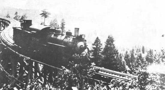
They built and maintained ditches to divert the Fresnal water to their crops and built the first dirt road from Fresnal to La Luz.. Fresnal, later known as Wooten, had the first post office in the area, established in 1894. The coming of the railroad in 1898 opened up the area for the shipment of goods to market and development of the tourist trade. By 1899, trains went as far as Toboggan Canyon, where passengers were transferred to stagecoaches for the fmal miles to Cloudcroft. Freight depots and Wells Fargo offices were built in both High Rolls and Mountain Park. The railroad operated on a regular basis until World War II. It finally ceased operation in 1948.
The first official use of the High Rolls name was in 1901, when the post office was moved from Fresnal (Wooten) to High Rolls. The name, which was sometimes spelled as one word, Highrolls, supposedly came from the shape and elevation of the area as compared to the sharper peaks higher up. Mountain Park received its name from Edgar Cadwallader, who came there in 1903 with the intent to grow fruit and vegetables. Others settled in the area and the resulting orchards produced apples, cherries, peaches, pears, cauliflower, and cabbage. It became so successful that the post office was moved there from High Rolls in 1904.
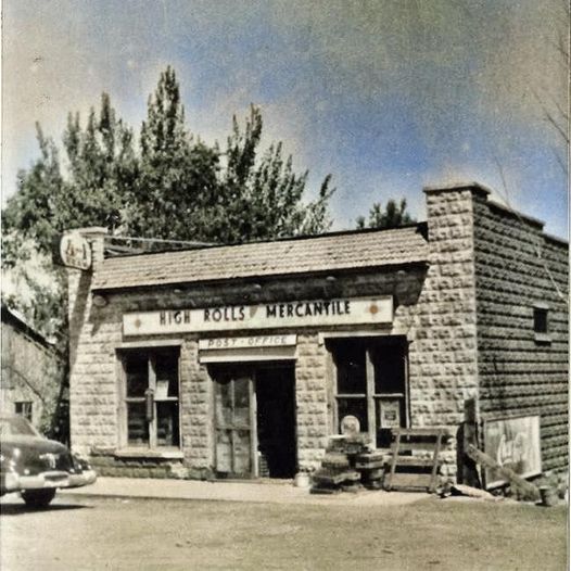
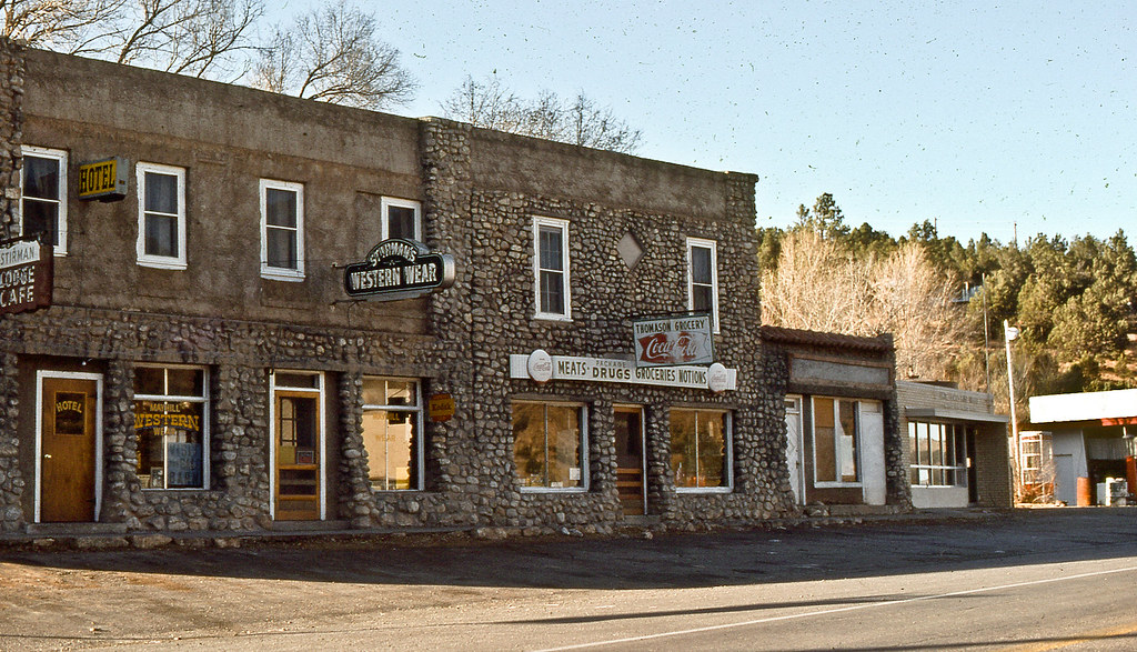
Other activities in the High Rolls/Mountain Park area included a poultry farm, a sawmill, a blacksmith shop and a shingle mill run by water from the Fresnal. The Courtney Mine shipped copper ore from its location 4 miles south of High Rolls. The first store was the High Rolls Mercantile Store, built in 1905; it is still standing on Railroad Drive in High Rolls. The original area school was a log cabin built in 1889. A school in Haynes Canyon was built in 1908 and the rock school in Karr Canyon was built in 1922 using some of the lumber from the old Haynes Canyon school. Although designed for indoor plumbing none was installed until 1944, because some school board members believed it was unnecessary.
The first church building was constructed of logs in 1888. In 1906, the Fresnal Baptist Church was built in Haynes Canyon. It is the present High Rolls/Mountain Park United Methodist Church, now a state historical site.
The High Rolls Development Company was formed in 1909 and built a three-story hotel with 25 rooms, which opened in 1912. The company also constructed about 50 guest cottages for summer visitors. Over the years, the hotel served as a tuberculosis sanitarium and later as a retreat for Jesuit priests. Finally, the hotel was dismantled, with part staying and becoming a private residence while other parts became homes in Alamogordo. Of the 50 cottages, only about six remain, all remodeled and added to, on what was known as Cottage Row.
The 160 acre Skyline Ranch of the YMCA was a well-known feature of the region from its start in 1908 as Camp Mescalero until it was sold and became private property in the 1980s.
Probably the best known native of the area is Bill Mauldin, nationally syndicated cartoonist, Pulitzer Prize winner and creator or World War II heroes Willie and Joe. Mauldin was born and raised in Mountain Park and his first cartoon appeared in the Alamogordo High School newspaper.
The two communities have grown over the years and are now considered by many to be one entity. At least the federal govermnent has since 1956, when it established the High Rolls/Mountain Park Post Office.
Author ’s note – information for this article was taken from the bool; Fresnal History, ana’]9’om the archives of the Sacramento Mountains Historical Museum.
The History of Mayhill
by Pat Rand
In the early 1850’s the U.S. government was having problems trying to maintain peace between the Mescalero Apaches and the white settlers who had recently begun homesteading in the area. The Indians would leave their reservation to steal horses, cattle, and sheep in order to survive. The settlers, fearing the Indians, asked the military for protection.
Capt. Henry W. Stanton, for whom Fort Stanton was named, and a party of soldiers were dispatched from San Patricio to search for Apaches. On January 18th, 1855, the Indians suprised the party as they traveled up the Penasco River. Stanton and several others were killed in the vicinity of present-day Mayhill. This historical incident is recorded on a marker in the village.
The village of Mayhill is situated on the eastern slopes of the Sacramento Mountains at an elevation of 6,500feet. It is located at the forks of the Rio Penasco and James Canyon, about 17 miles east of Cloudcroft on US Highway 82, at its junction with US Highway 130 to Weed.
Albert Coe, who had come to new Mexico in 1867 and whose brother Frank and cousin George were involved with Billy the Kid in the Lincoln County Wars, arrived in the Rio Penasco area in 1873 and settled on what is now the Jim Mahill ranch, about 1/2 mile east of the present village. One of the log cabins he built still stands on the homestead.
Soon, other settlers began coming into the area, including Charles Arthur (1884), Teen Clayton (1883), Joe Curtis (1880), John Gardessler (1880), Ben Henry (1882), Aled & Kim Hunter (1884), John James (1879), Henry Kepler (1884), Robert McGee (1878), W.C. Warren (1878), and John G. White (1878).
In 1881, Albert Coe returned to his former home in Missouri and married his childhood sweetheart Mary (Molly) Mahill. They returned to the Penasco for their honeymoon. One year later, Molly’s parents, John and Sara Mahill and their family joined them.
John Mahill bought the land covering the present village site from John James, for whom James Canyon was named, for $300 in December of 1882 and built an adobe house, which is still standing and occupied by family members.
The first post office, called Upper Penasco, was established in 1885. It was located in the Coe residence and Molly Coe was the first postmaster. In 1904 after several moves, the post office was permanently located and the village was officially named Mayhill, rather than Mahill, apparently through an error by the Postal Department. Attempts to correct the misspelling have been in vain.
Over the years, more people have settled in the fertile valley and Mayhill today continues to thrive with its farming and ranching industries. The lumber business is another activity in the area. Tourists are attracted to Mayhill in the summertime to enjoy the cool clear atmosphere, and each fall hundreds of deer hunters invade the region to enjoy the sport in the wide-open spaces ofthe Sacramento Mountains.
Author ’s Note: Information for this article was taken from the archives of the Sacramento Mountains Historical Museum and Research Center.
The History of Cloudcroft
More than a century ago, brothers Charles Bishop Eddy and John Arthur Eddy—organizers of the El Paso and Northeastern Railroad— arrived in the brand new town of Alamogordo, hoping to continue the rail line. Because they needed railroad ties and timber, the brothers sent a survey crew into the nearby Sacramento Mountains to assess the possibility of laying a line that reached the summit. In the fall of 1898, the crew reported that not only could a line be built, the area’s majestic beauty would draw visitors from far and wide. The crew suggested the name Cloudcroft,“a pasture for the clouds.”
By the end of 1898, the railroad line reached Toboggan Canyon. The following summer, John Arthur Eddy officially opened the Pavilion at the summit that provided accommodations for visitors including a kitchen, dining room, parlor, entertainment hall and 40 tents set on wooden platforms. Guests attended the festivities by taking the train to Toboggan Canyon and then a stagecoach up to Cloudcroft. The new resort received rave reviews in El Paseo and other area newspapers, and crowds began to visit the area. Fire twice destroyed the Pavilion but it was rebuilt each time in its original style.
The railroad line reached Cloudcroft in early 1900 and after the depot was built, “meeting the train” became a daily festivity in the village. Three trains pulled in to Cloudcroft daily to carry passengers and mail and haul logs down the mountain. Eventually, cars and trucks began to replace the trains, resulting in the railroad’s loss of money and eventual showdown. The last passenger train pulled in to the station in 1938 and the final freight train descended the hill in 1947.
Cloudcroft has changed little across the decades, retaining its famous friendly, small-town atmosphere. Visitors travel here from around the country as well as the world to enjoy the laid-back atmosphere, pristine wilderness and all the amenities of modern life.
History of Weed, NM
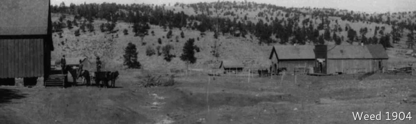
In December of 1885, a post office was established at a wide spot in Agua Chiquita Canyon, which was somewhat central for the area and a natural crossroads. The post office was named for W.H. Weed, a prominent White Oaks merchant, born and raised in New York City who had come to that mining town about 1882. There is no evidence that he ever visited the Agua Chiquita, but he set up a branch store there which became Weed as others built around it. The post office changed locations eight times in the next ten years.
The exact date of settlement in the Weed area is difficult to pin down. Scouts and hunters had entered the southeastern canyons of the Sacramentos as early as 1875. Cattle companies, looking for new water and grasslands, began running cattle into the mountains by 1880. The attractive qualities of the area were noted and the word was carried out by early visitors back to Texas and other states.
Albert Coe, who scouted for the Army, saw the Weed area in the 1870s and tried to settle on the Rio Penasco at the time. He soon left, got married and returned to the area in 1881, moving to Weed in 1887. In 1881, William O. Robertson scouted the region. Upon his return to San Saba, Texas he described the mountain to his neighbors and friends and the exodus began. In 1884, the J.W. Buckner, Dave Lewis, Bishop Fletcher and McBride families left for Mescalero and moved to Weed the following year. By 1888, Thomas Farr Fleming, Felix Sanders and Tilman Jones had traveled from San Saba to join Richardson.
In the 1890s the Ehart, David P. Allen and J.N. Daugherty families arrived. The Daughertys were encouraged to make the move by their famous in-law, Charles Goodnight. Jacob Gregg emigrated in 1897. Many notable citizens of the Weed area came from Texas before 1896, including G.W. Lewis and John Prather in 1884; G.E. Miller in 1886; Marion Pendergrass in 1887; the Potters, Parkers and Van Winkles in 1888; and G.W. Ivans and John Cridebring in 1895.
Other people who have been identified as being in the area by the year 1885 include Captain Wilkinson, Jim Baird, A.C. McDonald, McPherson and Biggs Booth, the Rev. John Hunter, William Ratliff, William Miller, Mary Hughes, Lucretia Miller, W.W. Davis, Amos McKeen, Frank Garst, L.W. Neatherlin, John Mack, F.E. McCleary, A.F. McEwan, D. Penrod, E.O. Thomas, W.R. Keeny, Nelson Davis, Tulk, W.J. Green, C.F. Hilton, P.G. Lemons, Wayland and sons, Washburn, Woods, Watts and Wilcox.
Most Weed settlers had traveled by wagon to the vicinity of Carlsbad, up the Pecos to the mouth of the Penasco and went west to Agua Chquita Creek. Some, however, took roundabout routes to the mountains. Thomas Day and James Wayland had both tried California before settling in the Sacramentos. Thomas W. Jones made the trip from the east to Weed via Arizona. Jesse de Prado MacMillan came to the Agua Chiquita from Scotland in 1903, stayed a few years near her cousin, Mary Tod Westlake, from Canada, and moved to California. The Munson and Calkins families traveled about before settling in the Weed area.
Weed remained the center of the region, although the surrounding communities reduced its importance after 1900, when the Federal Census showed the population of Weed to be 429 people. Weed settled into a sleepy isolation where a small, stable population of sawmillers, stockmen, farmers and merchants had developed.
Through the years, the population has declined and the Weed school, which was established in 1885 and had taken the children of the surrounding communities was closed in 1991. The students were transferred to the Cloudcroft district. In spite of this loss and a population of only 40 people, the people of Weed have maintained a strong kinship to each other and, in June 1995, celebrated Weed’s 110th year attracting more than 1,000 visitors.
• Historical information was obtained from the archives of the Sacramento Historical Museum and Research Center.
History of Piñon
The area was originally settled by the agricultural and hunter gatherer Jornada Mogollon people, circa 200 CE, whose suzerainty ended with the influx of the Apache and other plains raiders in approximately 1450.[6] The town was named in 1907 by the local school teacher John W. Nations after the piñon pine trees in the area.